進口程序準備中,近期開放購買。
注意:目前價格僅供參考。
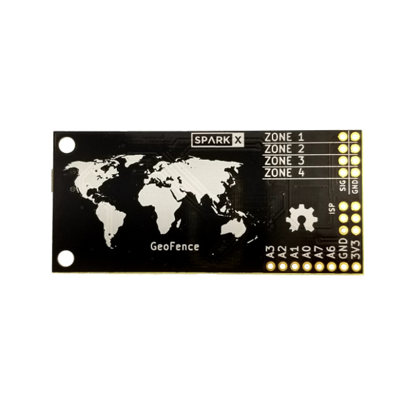
GeoFence - GPS邊界小部件
原名
GeoFence - GPS Boundary Widget
貨號
SPX-14416
特價
2,143
資料來源:https://www.sparkfun.com/products/14416
The GeoFence is designed to make it easy for you to add geofencing capabilities to your next project! If you’re not familiar with the idea of a geofence, no worries, it’s exactly what it sounds like:
…a virtual geographic boundary, defined by GPS or RFID technology, that enables software to trigger a response when a mobile device enters or leaves a particular area…
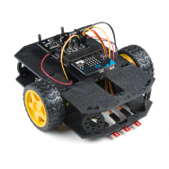
These are perfect for applications like fleet or asset management as well as puzzle games like Mikal Hart’s Reverse Geocache™ or our own Robert Cowan’s NCWP Scavenger Box.
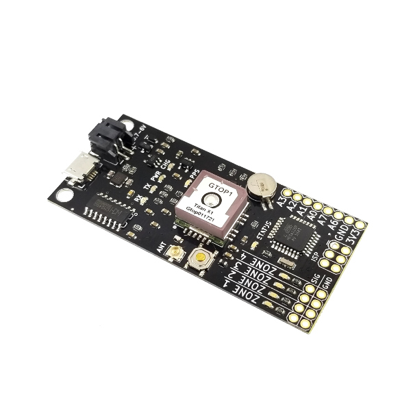
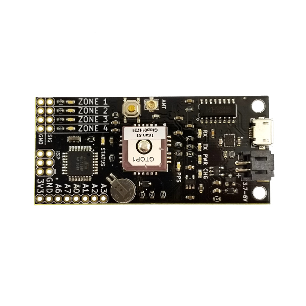
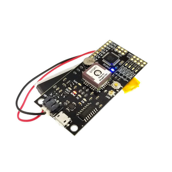
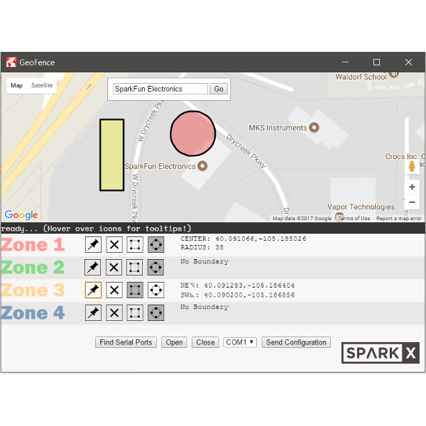
Using the GeoFence app, simply click and drag zones on a map to define areas that you want the board to trigger on. The board has four zone indicator LEDs. Whenever the board enters one or more of the zones you’ve selected, the corresponding LEDs will light and the appropriate zone indicator pins will flip from logic low to logic high. There’s also a system status pin that indicates when the GeoFence board is receiving valid GPS data, this allows another controller to validate the zone indicators if you incorporate the GeoFence into your larger project.
You can power the GeoFence through the on-board JST connector using a single cell lithium battery or, if you already have a regulated 3.3V source, through the 3V3 and GND breakouts. The ceramic antenna built into the Titan X1 GPS module works really well most cases, but if you’re going to put the GeoFence board in a project enclosure, you can connect an external GPS antenna using the U.FL connector located beside the reset button.
The GeoFence app is written in JavaScript for Electron. The source is available on our GitHub repository so you can build it for your Windows, Mac or Linux environment. If you’re running 64-bit Windows, we’ve built an executable installer to make it easy to get up and running.
We do not plan to regularly produce SparkX products so get them while they’re hot!
Experimental Product: SparkX products are rapidly produced to bring you the most cutting edge technology as it becomes available. These products are tested but come with no guarantees. Live technical support is not available for SparkX products. Head on over to our forum for support or to ask a question.
Features:
- Titan X1 GPS module allows for quick cold-start times (15 seconds) and the on-board RTC backup battery means the module will warm-start (5 seconds) even after 15 days without power!
- Built-in LiPo Battery Charger and Regulator allows the GeoFence to charge a connected single cell lithium battery using the USB port.
- Four zone indicator LEDs and zone status pins correspond to four software configurable geofences.
- GeoFence zones can be rectangular or circular and configuration is as easy as clicking on a map!
- ATmega328P microcontroller running at 8MHz with the Arduino Bootloader installed so you can easily write custom firmware.
- Six ADC-capable GPIO pins broken out from the ATmega328P, System Status pin on A0 by default.
Documents:
- Schematic
- KiCAD Files
- GeoFence Application Source
- GeoFence 64-bit Windows Installer
- GeoFence Getting Started Guide
- GPS Module Titan X1 Datasheet
- To get the latest files please visit the GitHub repo
GeoFence旨在讓您輕鬆地為下一個項目添加地理圍欄功能!如果你不熟悉地理圍欄的想法,不用擔心,這聽起來就像這樣:
...由GPS或RFID技術定義的虛擬地理邊界,可使軟件在移動設備進入或離開特定區域時觸發響應。
這些是完美的應用程序,如艦隊或資產管理以及益智遊戲,如Mikal Hart的反向Geocache™或我們自己的Robert Cowan的NCWP清道夫盒 。
使用GeoFence應用程序,只需在地圖上單擊並拖動區域即可定義您希望板觸發的區域。該板有四個區域指示燈。每當闆卡進入您選擇的一個或多個區域時,相應的LED將亮起,相應的區域指示器引腳將從邏輯低電平翻轉為邏輯高電平。還有一個系統狀態引腳,指示GeoFence板何時正在接收有效的GPS數據,如果將GeoFence合併到較大的項目中,則允許另一個控制器驗證區域指示器。
您可以使用單節鋰電池通過板載JST連接器為GeoFence供電, 或者如果您已經通過3V3和GND 突點已經有3.3V的穩壓源。內置在Titan X1 GPS模塊中的陶瓷天線在大多數情況下工作得非常好,但如果要將GeoFence板放在項目機箱中,則可以使用位於復位按鈕旁邊的U.FL連接器連接外部GPS天線。
GeoFence應用程序用JavaScript for Electron編寫。源代碼可在我們的GitHub存儲庫中獲得,因此您可以為Windows,Mac或Linux環境構建源代碼。如果您運行的是64位Windows,我們已經構建了一個可執行的安裝程序,以便輕鬆啟動和運行。
我們不打算定期生產SparkX產品,讓他們在熱的時候得到它們!
特徵:
- Titan X1 GPS模塊允許快速冷啟動時間(15秒),並且板載RTC備用電池意味著即使15天后,模塊也將啟動(5秒),無需電源!
- 內置LiPo電池充電器和穩壓器允許GeoFence使用USB端口為連接的單節鋰電池充電。
- 四個區域指示燈和區域狀態引腳對應於四個軟件可配置的地理圍柵。
- GeoFence區域可以是矩形或圓形,並且配置與點擊地圖一樣簡單!
- ATmega328P微控制器運行在8MHz的Arduino Bootloader安裝,所以你可以輕鬆地編寫自定義固件。
- 默認情況下,從ATmega328P,A0上的系統狀態引腳中分離出六個支持ADC的GPIO引腳。
文件: